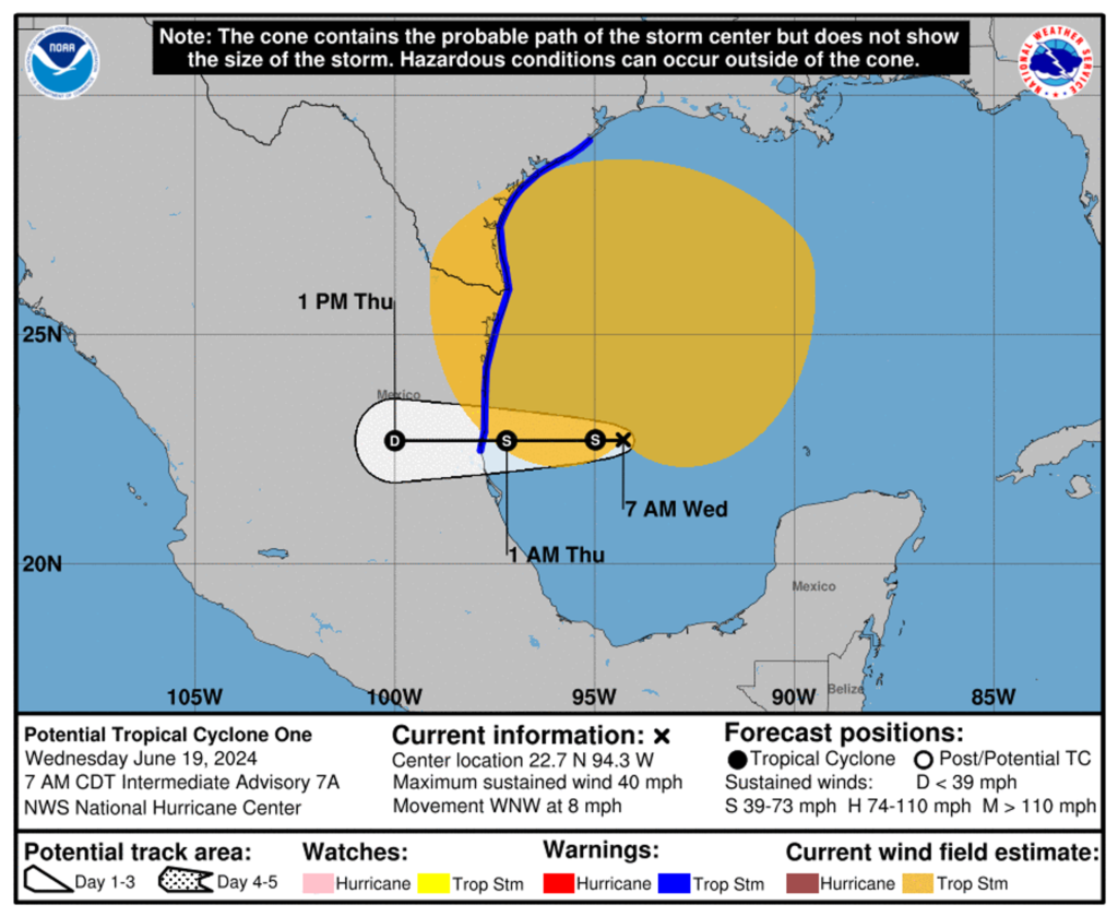
In a developing weather situation that has captured the attention of meteorologists, Tropical Storm Alberto has officially formed and is projected to make significant impacts along various coastlines. Here is the latest update on Alberto’s formation, its current trajectory, and what to expect in the coming days.
Tropical Storm Alberto Takes Shape, Threatens Coastlines
Tropical Storm Alberto formed late last night in the warm waters of the Caribbean, quickly garnering attention from weather agencies and residents along the coastlines. With sustained winds currently clocked at 45 miles per hour, Alberto is expected to gain strength as it moves northward. Forecasters are watching closely as the storm makes its slow but steady progression, with the potential to escalate into a more severe weather event.
The National Hurricane Center has issued several alerts and warnings, particularly for areas most likely to be impacted by Alberto’s path. Coastal regions from Florida to Louisiana are on high alert, with local governments preparing for possible evacuations and emergency response measures. While it’s still early in the storm’s development, the potential for heavy rainfall, flooding, and storm surges is significant, hence the urgent calls for preparedness.
Residents in the projected path of Tropical Storm Alberto are advised to stay updated through official weather channels and heed any safety advisories. The storm’s unpredictable nature means that conditions could change rapidly, making it crucial for those in vulnerable areas to be ready for any eventuality. As the situation develops, continuous monitoring and timely action will be key to mitigating the storm’s impact.
Alberto’s Path and Potential Impact
As of the latest reports, Tropical Storm Alberto is moving northwest at a speed of approximately 10 miles per hour. The storm’s current trajectory suggests that it will approach the Gulf Coast within the next 48 to 72 hours. Meteorologists are employing advanced tracking systems to predict Alberto’s precise path, although the inherent uncertainty in tropical storm behavior necessitates a wide cautionary zone.
The potential impacts of Tropical Storm Alberto are varied and could be severe. Rainfall amounts are expected to range from 4 to 8 inches, with isolated areas possibly receiving up to 12 inches of rain. This magnitude of precipitation could lead to flash flooding, particularly in low-lying areas and regions with poor drainage systems. Coastal areas may also experience storm surges, which, combined with high tides, could result in significant coastal erosion and damage to infrastructure.
High winds and the possibility of isolated tornadoes add another layer of risk associated with Alberto. These winds can uproot trees, down power lines, and cause widespread power outages. Communities are advised to secure loose items, reinforce structures, and have emergency kits prepared. The National Weather Service continues to update its forecasts as new data becomes available, providing the public with the most accurate and timely information possible.
As Tropical Storm Alberto advances, the importance of preparedness and vigilance cannot be overstated. The storm’s potential to cause widespread disruption underscores the need for residents in affected areas to stay informed and take precautionary measures. By keeping abreast of the latest weather updates and following official guidelines, communities can better protect themselves and minimize the storm’s impact. Stay tuned to reliable news sources for ongoing coverage and updates as the situation unfolds.


